Antiquities - renains of najran city
Abar Hama – Najran:
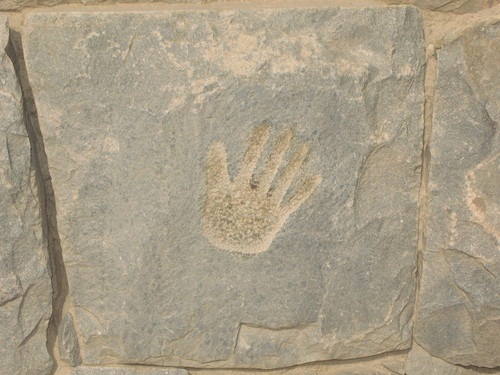
In Abar Hama there are some 300 different locations containing stone engravings and drawings, including prehistoric depictions of animals. You'll find engravings of human figures and giraffes which date from around 5500 BC.
The area is a little difficult to reach, but the journey is worth it. Once there you'll see evidence of Neolithic settlements in the Abar Hama area at Wadi Tathlith, and Jebel Sawdh. The drawings were made the climate was milder and more humid, allowinAt the time g basic cultivation and the domestication of sheep and cattle to take place. Petroglyphs and inscriptions are found in particularly high concentrations in the Abar Hama, Yadmah and Jebel al-Qarrah areas and can be found adjacent to wells, springs and watercourses which once supported permanent, nomadic and transit populations. At that time the camel was being domesticated and the people of Arabia were able to evolve a nomadic and tribal culture.
The Abisha fresco around Jebel al Qarrah feature fat-tailed sheep which are still bred in the area. Other illustrations include cattle, ibex, lion, camels, ostrich, a baboon, hunting people, people fighting and people performing ritual dances. In some cases, human figures are depicted with wusum - motifs that signify clan affiliations.
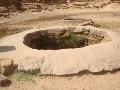
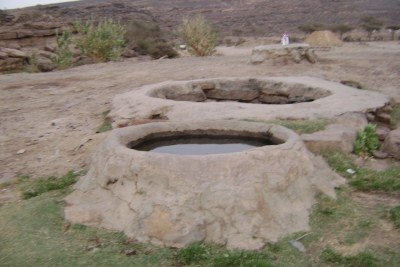
You can see rock carvings and mosaics depicting such scenes as date harvesting. You will see an ancient irrigation well that still holds water, and explore the fringes of The Empty Quarter, or Rub Al Khali, and enjoy the sunset over the sand dunes.
Al-Ukhdood Archeological City – Najran:
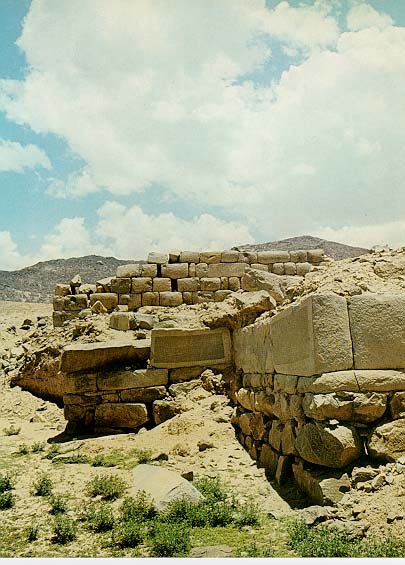
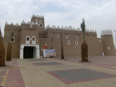
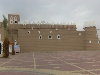
Al-Ukhdood Archeological City, previously called ( Raqmat ) , is considered one of the most important archeological sites in Najran region The location of Al-Ukhdood city is the same location where the old Najran city existed. It lies at the Al-Qabel village at the southern edge of the Najran valley. The site consists of a city surrounded by a wall 235 meters in length and 220 meters in width.
Al-Ukhdood founded as early as the 7th century BC, this former farming community survived possibly until the 10th century AD The name Al-Ukhdood means 'the ditch', sometimes 'the trench', sometimes 'the groove
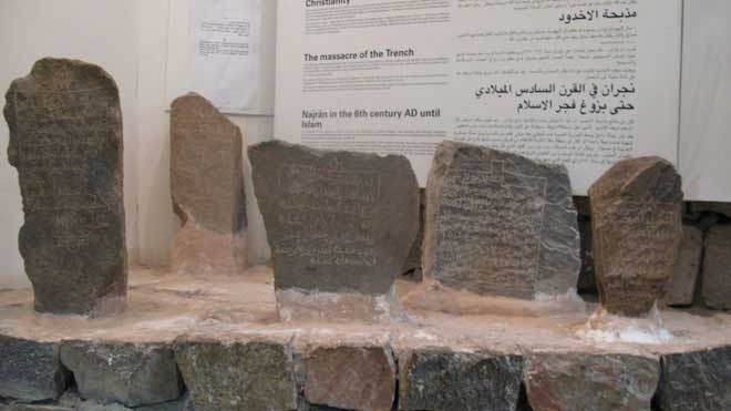
Al-Ukhdood is mentioned in the ( Holy Quran ) as being the site of a massacre of in Christians in (525) 101BH. This event is sometimes referred to as the massacre of the Najran martyrs. (( Cursed were the People of the Ditch . Of fire fed with fuel . When they sat by it . And they witnessed what they were doing against the believers . And they had no fault except that they believed in Allah , the Almighty , Worthy of all praise ! To Whom belongs the dominion of the heavens and the earth ! And Allah is Witness over everything ))
The Frankincense Trade Route from Yemen passed through Al-Ukhdood (the town now known as Najran) on its way to Makkah, Madinah and then on to Palestine, Syria, the Arabian Gulf and Mesopotamia.
Cities along the main caravan routes were able to levy taxes on the merchants, and in this way they became rich. At its peak, Al-Ukhdood was one of the most important trading cities in Southern Arabia and its wealth was demonstrated by the high quality construction of the main buildings. There still remain substantial areas of dressed stone, and ornate bronze drain spouts.
Al-Ukhdood declined in importance when trades discovered how to sail to India on the monsoon winds. Around the same time there was a decline in demand for frankincense when Christianity became the state religion of the Roman Empire in 235BH (395). The resurgence of Najran and the settlements around Al-Ukhdood was mainly due to the rise of Christianity in the area and the influence of Byzantium in the centuries before Islam.Dhu Nuwas laid siege to Al-Ukhdood. When the town capitulated, the inhabitants were given an impossible choice - convert or die. They chose the latter and thousands were thrown into a burning ditch.
The ditch (which may be a defensive moat) is still visible, and archaeologists have found evidence of burning which supports the written accounts of the tragedy. In revenge for this attack the Ethiopians (Abyssinians) invaded and deposed Dhu Nuwas. For the next few decades, the area was under Abyssinian rule
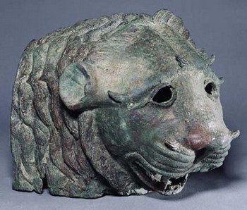
The castle represents the main period of settlement in Al-Ukhdood, which may have continued till the end of the third century. This area coincided with the flourishing of the civilization of south of the Arabian peninsula as well as the period after the civilization of south of the Arabian Peninsula and the Islamic civilization period Al-Ukhdood contains a lot of sculptures, wonderful drawings, Sabaeans and Kuffis Calligraphist. although picking your way through the crumbling stone walls and searching for Thaumidic inscriptions can be a pleasant way to pass a time.
Najran Dam – Najran:
Najran Dam one of the region's tourist attractions and is considered one of the most beautiful touristy places with its natural charming view, giving visitors the opportunity to enjoy scenic views on both sides of the dam.
The dam is cylindrical arch 0f radius 140m and width 9.5m .Its greatest height from foundation to crest is 73m and contains 110.000 cubic meters of concrete . A 4.5m wide crest road including the bridge over the spillway is incorporated Internal temperatures have been controlled subsequently by pumping cold water through a system of 25mm diameter pipes embedded in the concrete .To ensure monolithic behavior of the structure ,the joints between each block have pressure grouted once the dam had been cooled to temperature of 22 oC.
A system of monitoring devices was incorporated into the dam. Vertical and horizontal deflection of the dam foundations are measured by hanging pendula and by extensometers anchored into rock. The water pressures beneath the dam and in the abutments are monitored by piezometers. The temperature cells record the temperature in several parts of the dam , the upstream water level and the amount of discharge from the gates is recorded automatically to give a clear picture of the exact amount of discharged water.
Outlet Works
Flood discharge can be affected through :-
A-Spill way
A 69m wide overflow spill way is incorporated in the dam crest . The design capacity of the spill way is 8200 cubic meter per second with a head of 15m over the spill way crest .
B-Normal Release
Three 2.25m diameter outlets are provided near the base of the dam , controlled by sliding gate valves at the downstream face . These outlets will allow some of the sediment suspended in the reservoir in-flows to pass through the dam . Trash screens prevent large materials which may damage the outlets from entering . The control valves are each protected by ring follower valve and there is provision for stop logs behind the trash screen . The discharge capacity of each outlet at normal conservation level is 65 cubic meter per second . An additional 2.25m outlet with a discharge capacity of 55 cubic meter per second is provided 17m above the lower outlets .The jet dispersing (sleeves) valve controlling the flow is protected by a trash screen and a fix wheel gate.
C-Drawn down
Should it be necessary for maintenance purposes , water remaining in the reservoir below the level of the outlets can be drained by 0.5m diameter drain outlet .
Downstream dam and plunge pool
Water levels below the main dam are controlled by a low dam 150m downstream. The pool of water retained will cushion the impact of water discharging over the spill way during major flood and thus limit the depth of scour hole that will develop . Two concrete walls anchored to the base of the abutments limit the horizontal extent of the scour hole . The downstream dam has an 80m wide flat V profile and also acts as measuring weir.
Roads and tunnels
The project has two access roads, one 6.5km long provides access to dam from Mofija to the right abutment . The other , a 0.7km upstream access decends from the top of the left abutment to the upstream apron of the dam.
Most of the road from Mofija is benched into the side of the gorge at a minimum height of 3.5m above valley bed level. The road passes through two tunnels 1500m and 400m long respectively with a cross section 6m wide and 5m high and also spans the valley on a 50m long concrete bridge . The road and bridge will remain dry for valley flows up to 500 cubic meter per second but will be submerged by the rare flows greater than this.
Valley bank protection
Downstream of the dam where the valley banks are particularly vulnerable to attack by flow , rock armoring is being placed . A total of 37000 cubic meter of rocks are used to protect 7.5km of bank line . An economical fence type of protection was used to cover 7km of bank line elsewhere. The Najran Valley Dam, with a storage capacity of 86 million cubic meters (3,000million cubic feet), it cost total 772 million Saudi Riyals The people of Najran is very proud of their dam.
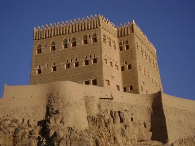
Al-Aan Palace – Najran:
A heritage palace called Saddan, located on the Al-Aan mountain, built in 1100H (330) years ago. This palace was built of mud on stone foundations in an architectural style which is the characteristic of the area surrounded by a wall of mud. It is located in the western side of Najran city. The Al-Aan Palace is one of the most remarkable pieces of architecture in the Wadi Najran. The main tower is four storeys high and dominates the oasis from the summit of a rocky outcrop. Built as a self-sustaining complex, including livestock pens and its own mosque. You can't go into the building because people live there, but there's an excellent view from the car park over the oasis.
Najran Museum – Najran:
Najran Museum is one of eight regional museums developed across the Kingdom of Saudi Arabia, It is located in the middle of Najran city. It was opened in 1416H (1995).. Visitors to the museum can learn about the early history of the region . They can see fragments of artifacts and tools that have been found, shards of pottery , and even poetry engraved on clay tablets. Folklore shows are held and traditional products are shown in the location. Visiting hours:
From 08.00 morning to 12.00 at noon .
From 15.00 to 18.00 in the evening.
Families visiting days :-
Sunday , Wednesday , Thursday and Friday.
Another museum in the Najran area, one of the Kingdom's newest and best, was historically a palace once used as the residence for the regional governor. There are at least two private museums in Najran ; one at the Najran Dam displays a small range of traditional household objects, and a private museum owned by Mr. Saied Bin Faraj.
The Historical Palace Of Emirate–Najran:
An old historical palace , Built in 1363H -1943G. Palace provides an ideal opportunity to learn about the history of the province in the last 100 years or so of the Saudi State.
The palace has 60 rooms that once served as government departments and stores, as well as accommodation for the governor and his family. A well that dates back to pre-Islamic times, and which still contains water, is located in the center of the courtyard. Currently, the museum has displays on valleys and deserts, archeological finds, local crafts and tools, and historic photos taken of the area in the early years of this century. The palace is considered as unique example of the distinguished traditional architecture.
Popular Market – Najran:
The market is near the historical palace of emirate and consists of many single storey buildings. This market is considered to be one of the most popular traditional markets in the Kingdom.
Even today, there are many craftsmen who still have stalls in this market. The market is well known for its traditional crafts such as colorful baskets ranging in size from small bowls to large breadbaskets with lids. Goatskin water coolers are also among the traditional crafts found in the market. Other traditional leather products include purses, bags for storing coffee and flour, and carrying-cots for infants. Women in the market sell old bedouin silver jewelry, while potters and weavers display their wares.The market has acquired a reputation for being one of the best places for tourists and sightseers to visit when in this area.
The Rub' Al Khali – Najran:
The Rub' Al Khali (Arabic:), which translates as Empty Quarter in English, is the vast expanse of desert that covers much of the Southern half of the Arabian Peninsula. It makes up about a third of Saudi Arabia and extends into both Yemen and Oman. Its size makes it one of the world's largest deserts, as it covers about 25,000 square miles (40,233 square km) of land. The harsh conditions of The Empty Quarter mean that it has seldom been inhabited or even explored by humans. The nomadic Bedouins that have lived on the Arabian Peninsula for thousands of years deliberately set up travel routes that would only skirt the edges of The Empty Quarter .This is not surprising, since on an average summer day. The temperature can easily rise to 131 degrees F (55 C). Surprisingly, the extreme temperatures of The Empty Quarter still allow for many species of birds, plants and insects to flourish. The Empty Quarter is of great importance from a natural resources standpoint. It is generally considered to have the highest amount of untapped oil. Some of the largest oil fields in the world extend into this forbidding desert. Yet, the normal conditions of the desert life make it hard to stray too far into The Empty Quarter. At one point, before 300 BCE, some trade routes of the Bedouins did cross into The Empty Quarter , but these had to be planned very carefully. Some of the sand dunes in this dessert reach heights of over 1000 feet (304 m), making it an impossible climb for a slow moving caravan The Empty Quarter is a desert like no other, and includes the largest continuous body of sand dunes on the planet.
Traditional Buildings – Najran:
The houses in Najran are made of a special clay that is particular to this area, mixed with straw to provide the strong structural adobe walls that enable them to withstand the harsh climate. Ceilings are made of the spines of palm fronds, stripped of the foliage and covered in clay, laid atop wooden beams. This technique creates a cooling environment in the hot summer days and provides warmth in the winter. The buildings are made up of several stories. The lowest level is given over to livestock and can be without windows. The next level is for human habitation, and have small windows to keep out intruders. As you go up the building, the windows get larger to let in more light and air. Often these houses are clustered together around a central courtyard, so that members of the same family can live together These traditional buildings are still seen in many towns and villages, with some buildings well maintained (or restored) while others are deteriorating Fortunately, there seems to be considerable interest by some Najran residents to preserve their traditional homes - often modernizing them for current life styles.